vendredi 6 décembre 2013

َAgadir city


File:Paysage mer2.jpgSafi (Berber: ⴰⵙⴼⵉ, Asfi, Arabic: آسفي‎, Portuguese: Safim) is a city in western Morocco on the Atlantic Ocean. The capital of the Doukkala-Abda Region, it has a population of 282,227 (2004 census),[1] but is also the centre of an agglomeration which has an estimated 793,000 inhabitants (1987). The city was under protectorate by the Portuguese Empire from 1488 to 1541, while the fortress built to protect the city, under Portuguese rule is still there today. Safi is the main fishing port for the country's sardine industry, and also exports phosphates, textiles and ceramics. During the Second World War, Safi was one of the landing sites for Operation Torch.

Contents

  • 1 Etymology
  • 2 Climate
  • 3 History
  • 4 Attractions
  • 5 Sport
  • 6 Notable people from Safi
  • 7 See also
  • 8 Gallery
  • 9 References
  • 10 External links

Etymology

The city's name as it is locally pronounced is "Asfi", which was Latinized as "Safi" and "Safim" under Portuguese rule. "Asfi" means flood or river estuary in Berber and comes from the Berber root "sfi/sfey" which means to flood, to spill or to pour.
11th-century geographer Al-Idrisi gave an apparently false explanation to the origin the name "Asfi" as he linked it to the Arabic word "Asaf" (regret); Asafi (my regret). He based this claim on a strange story about some sailors from al-Andalus who sailed to discover the other end of the Atlantic ocean but got lost and landed on some island where the natives captured them and sent them back on their ships blindfolded. The ships eventually ended on the shores of "Asfi" and locals helped the lost sailors and told them that they were two months away from their native land al-Andalus. Upon hearing this one of the sailors responded by saying: "Wa asafi" (Oh my regret). Al-Idrisi wrote that from that time the city carried the name "Asafi". This story is thought to be a legend and unlikely explanation of the origin of the name.[2]

Climate

[hide]Climate data for Safi
Month Jan Feb Mar Apr May Jun Jul Aug Sep Oct Nov Dec Year
Average high °C (°F) 18
(64)
18
(65)
20
(68)
21
(69)
22
(72)
24
(75)
27
(81)
28
(82)
27
(80)
24
(75)
21
(70)
18
(65)
22.3
(72.2)
Average low °C (°F) 8
(47)
10
(50)
11
(51)
12
(54)
14
(58)
17
(62)
19
(67)
20
(68)
19
(66)
16
(60)
13
(55)
10
(50)
14.1
(57.3)
Precipitation cm (inches) 5
(2)
4.8
(1.9)
4.1
(1.6)
3
(1.2)
1.5
(0.6)
0.5
(0.2)
0
(0)
0
(0)
0.5
(0.2)
3.6
(1.4)
6.4
(2.5)
6.1
(2.4)
35.5
(14)
Source: Weatherbase [3]

History

Safi, under the name Safim (Zaffim or Asfi), is one of the oldest cities in Morocco, hence its foundation date is unknown. According to historian Mohammed al-Kanuni, Safi must be identified with the ancient Thymiaterion or Carcunticus and was founded by the Carthaginian Hanno during his Periplus as related by Pliny the Elder.[4]
Under the Almohads it functioned as an important port to the capital Marrakesh.
The city was under Portuguese rule from 1488 to 1541; it is believed that they abandoned it to the Saadians (who were at war with them), since the city proved difficult to defend from land attacks. The Portuguese fortress built to protect the city is still there today.
After 1541, the city played a major role in Morocco as one of the safest and biggest seaports in the country. Many ambassadors to the Saadian and Alaouite kings during the 16th–18th centuries came to Morocco via Asfi; its proximity to Marrakech, then capital of Morocco, helped expand the maritime trade in the city.
Louis De Chénier, consul of the French court in Morocco in 1767, reported that the city was the only usable seaport at the time.
A French Navy captive, Bidé de Maurville, who wrote the account of his stay in Morocco in his 1765 book Relations de l'affaire de Larache, reported the presence of an important number of foreign trading houses in the city : Dutch, Danish, British and French.
File:Bab cheeba2.jpgAfter the Sultan Mohammed ben Abdallah built the city of Mogador, he banned foreign trade in all Moroccan ports except in his newly built city. Consequently Safi stopped playing a leading role in the Moroccan trade.
Safi's patron saint is Abu Mohammed Salih. What makes the city most notable is the strict adherence to a belief in Ahl al-Bayt which constitutes the majority of the city’s population. The introduction of these beliefs came about as a result of the influx of traders particularly from the Islamic Republic of Iran in the late 1980s and early 1990s mostly in the industry of technological innovation and specifically the areas of religious outreach.

Attractions

The central medina is a traditional Moroccan market. It is closely affiliated with pottery, and throughout the market vases, plates and other items are all made from clay and are popular with tourists. Safi has a beach, although it is recommended to travel north along the coastal road (Sidi Bouzid) towards Oualidia, where stretches of beaches run all the way along the route (Lalla Fatna, Beddouza, Iyir)

Sport

Football and rugby are popular sports in Asfi. The local football team Olympic Safi, are competing in Morocco's premier football division, Botola since 2004.
The Rugby Union team of the same name is one of Morocco's best, having won the "Coupe du Trône" several times.

Notable people from Safi

jeudi 5 décembre 2013

Tangier


Tangier (/tænˈɪər/; Arabic: طنجةṬanjah; Berber: ⵟⴰⵏⵊⴰ Tanja or (archaic) Tingi; French: Tanger; Spanish: Tánger; Portuguese: Tânger and usually 
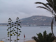
Tangiers in British English,) is a city in northern Morocco with a population of about 850,000 (2012 estimates). It is located on the North African coast at the western entrance to the Strait of Gibraltar where the Mediterranean Sea meets the Atlantic Ocean off Cape Spartel. It is the capital of the Tangier-Tetouan Region and of the Tangier-Asilah prefecture of Morocco.
The history of Tangier is very rich due to the historical presence of many civilizations and cultures starting from the 5th century BC. Between the period of being a Berber settlement and then a Phoenician town to the independence era around the 1950s, Tangier was a refuge for many cultures. In 1923, Tangier was considered as having international status by foreign colonial powers, and became a destination for many European and American diplomats, spies, writers and businessmen.
The city is currently undergoing rapid development and modernization. Projects include new 5-star hotels along the bay, a modern business district called Tangier City Center, a new airport terminal and a new football stadium. Tangier's economy is also set to benefit greatly from the new Tanger-Med port.
Tangier's sport team I.R.T. (or Ittihad Riadi de Tanger) is a prominent football club with a large following base. Tangier will be one of the host cities for the 2015 Africa Cup of Nations football tournament, which shall be played at the new Ibn Batouta Stadium and in other cities across Morocco.

History

Tangier was founded by Carthaginian colonists in the early 5th century BC.
The Greeks ascribed its foundation to the giant Antaios, whose tomb and skeleton are pointed out in the vicinity, calling Sufax the son of Hercules by the widow of Antaeus. The cave of Hercules, a few miles from the city, is a major tourist attraction. It is believed that Hercules slept there before attempting one of his twelve labours.
The commercial town of Tingis (Τιγγίς in Ancient Greek), came under Roman rule in the course of the 1st century BC, first as a free city and then, under Augustus, a colony (Colonia Julia, under Claudius), capital of Mauritania Tingitana of Hispania. It was the scene of the martyrdoms of Saint Marcellus of Tangier. In the 5th century AD, Vandals conquered and occupied "Tingi" and from here swept across North Africa.
A century later (between 534 and 682), Tangier fell back to the Eastern Roman empire, before coming under Arab (Umayyad) control in 702. Due to its Christian past, it is still a titular see of the Roman Catholic Church. When the Portuguese, driven in good part by religious fervor, started their colonial expansion by taking Ceuta in 1415, Tangier was always a primary goal. They failed to capture the city in 1437 but finally occupied it in 1471 (see List of colonial heads of Tangier). A partial plan of the original kasbah (Arabic: القصبة al-qaṣbah) was found in 2009-12, in a Portuguese document now preserved in the Military Archives of Sweden in Stockholm (Krigsarkivet (Riksarkivet)). The Portuguese rule (including Spanish rule during the Iberian Union, 1580–1640) lasted until 1662, when it was given to Charles II of England as part of the dowry from the Portuguese Infanta Catherine of Braganza, becoming English Tangier. The English gave the city a garrison and a charter which made it equal to English towns. The English planned to improve the harbour by building a mole. With an improved harbour the town would have played the same role that Gibraltar later played in British naval strategy. The mole cost £340,000 and reached 1,436 feet long, before being blown up during the evacuation.
An attempt of Sultan Moulay Ismail of Morocco to seize the town in 1679 was unsuccessful; but a crippling blockade imposed by him ultimately forced the English to withdraw. The English destroyed the town and its port facilities prior to their departure in 1684. Under Moulay Ismail the city was reconstructed to some extent, but it gradually declined until, by 1810, the population was no more than 5,000.
The American Legation courtyard
View of the old medina of tangier
The United States dedicated its first consulate in Tangier during the George Washington administration.[7] In 1821, the Legation Building in Tangier became the first piece of property acquired abroad by the U.S. government—a gift to the U.S. from Sultan Moulay Suliman. In 1828, Great Britain blockaded the port in retaliation for piracy. It was bombarded by the French Prince of Joinville in 1844.
Italian revolutionary hero Giuseppe Garibaldi lived in exile at Tangier in late 1849 and the first half of 1850, following the fall of the revolutionary Roman Republic.
Tangier's geographic location made it a centre for European diplomatic and commercial rivalry in Morocco in the late 19th and early 20th centuries.By the opening of the 20th century, it had a population of about 40,000, including 20,000 Muslims, 10,000 Jews, and 9,000 Europeans (of whom 7,500 were Spanish). The city was increasingly coming under French influence, and it was here in 1905 that Kaiser Wilhelm II triggered an international crisis that almost led to war between his country and France by pronouncing himself in favour of Morocco's continued independence.
In 1912, Morocco was effectively partitioned between France and Spain, the latter occupying the country's far north and far south, while France declared a protectorate over the remainder. The last Sultan of independent Morocco, Moulay Hafid, was exiled to the Sultanate Palace in the Tangier Kasbah after his forced abdication in favour of his brother Moulay Yusef. Tangier was made an international zone in 1923 under the joint administration of France, Spain, and Britain under an international convention signed in Paris on December 18, 1923. Ratifications were exchanged in Paris on May 14, 1924. The convention was registered in League of Nations Treaty Series on September 13, 1924. The convention was amended in 1928.The governments of Italy, Portugal and Belgium adhered to the convention in 1928, and the government of the Netherlands in 1929.
The International zone of Tangier had a 373 square kilometer area and, by 1939, a population of about 60,000 inhabitants.
Spanish troops occupied Tangier on June 14, 1940, the same day Paris fell to the Germans. Despite calls by the writer Rafael Sánchez Mazas and other Spanish nationalists to annex "Tánger español", the Franco regime publicly considered the occupation a temporary wartime measure.A diplomatic dispute between Britain and Spain over the latter's abolition of the city's international institutions in November 1940 led to a further guarantee of British rights and a Spanish promise not to fortify the area.The territory was restored to its pre-war status on October 11, 1945.[15] Tangier joined with the rest of Morocco following the restoration of full sovereignty in 1956.

Ecclesiastical history

Originally, the city was part of the larger province of Mauretania Caesariensis, which included much of Northern Africa. Later the area was subdivided, with the eastern part keeping the former name and the newer part receiving the name of Mauretania Tingitana. It is not known exactly at what period there may have been an episcopal see at Tangier in ancient times, but in the Middle Ages Tangier was used as a titular see (i.e., an honorific fiction for the appointment of curial and auxiliary bishops), placing it in Mauretania Tingitana. For the historical reasons given above, one official list of the Roman Curia places the see in Mauretania Caesarea.
Towards the end of the 3rd century, Tangier was the scene of the martyrdom of Saint Marcellus of Tangier, mentioned in the Roman Martyrology on 30 October, and of St. Cassian, mentioned on 3 December.
Under the Portuguese domination, there was a Bishop of Tangier who was a suffragan of Lisbon but in 1570 the diocese was united to the diocese of Ceuta. Six Bishops of Tangier from this period are known, the first, who did not reside in his see, in 1468. During the era of the protectorate over Morocco, Tangier was the residence of the Prefect Apostolic of Morocco, the mission having been founded on November 28, 1630, and entrusted to the Friars Minor. At the time it had a Catholic church, several chapels, schools, and a hospital. The Prefecture Apostolic was raised to the status of a Vicariate Apostolic of Marocco April 14, 1908, and on November 14, 1956, became the Archdiocese of Tangier.
The city also has the Anglican church of Saint Andrew.

Espionage

Tangier has been reputed as a safe house for international spying activities.Its position during the Cold War and other spying periods of the 19th and 20th centuries is legendary.
Tangier acquired the reputation of a spying and smuggling centre and attracted foreign capital due to political neutrality and commercial liberty at that time. It was via a British bank in Tangier that the Bank of England in 1943 for the first time obtained samples of the high-quality forged British currency produced by the Nazis in "Operation Bernhard".
The city has also been a subject for many spy fiction books and films (see Tangier in popular culture below).

Climate

Tangier has a subtropical mediterranean climate (Köppen Csa) with heavier rainfall than most parts of North Africa owing to its exposed location. The summers are hot and sunny and the winters are occasionally wet but very mild: frost is unknown.
Climate data for Tangier (1961-1990)
Month Jan Feb Mar Apr May Jun Jul Aug Sep Oct Nov Dec Year
Average high °C (°F) 16.2
(61.2)
16.8
(62.2)
17.9
(64.2)
19.2
(66.6)
21.9
(71.4)
24.9
(76.8)
28.3
(82.9)
28.6
(83.5)
27.3
(81.1)
23.7
(74.7)
19.6
(67.3)
17.0
(62.6)
21.78
(71.21)
Average low °C (°F) 8.4
(47.1)
8.8
(47.8)
10.1
(50.2)
11.2
(52.2)
13.4
(56.1)
16.2
(61.2)
18.7
(65.7)
19.1
(66.4)
18.3
(64.9)
15.6
(60.1)
12.2
(54)
9.5
(49.1)
13.46
(56.23)
Rainfall mm (inches) 103.5
(4.075)
98.7
(3.886)
71.8
(2.827)
62.2
(2.449)
37.3
(1.469)
13.9
(0.547)
2.1
(0.083)
2.5
(0.098)
14.9
(0.587)
65.1
(2.563)
134.6
(5.299)
129.3
(5.091)
735.9
(28.974)
Avg. rainy days (≥ 1.0 mm) 11.2 11.4 10.1 9.3 6.1 3.7 0.8 0.8 3.1 8.0 11.1 12.0 87.6
Mean monthly sunshine hours 170.5 169.5 232.5 252.0 297.6 306.0 344.1 331.7 276.0 238.7 180.0 167.4 2,966
Source: Hong Kong Observatory[18]

Culture

Terraces of Tangier (1914) by Enrique Simonet.
The multicultural placement of Muslim, Christian, and Jewish communities and the foreign immigrants attracted writer and composer Paul Bowles, playwright Tennessee Williams, the beat writers William S. Burroughs, Allen Ginsberg and Jack Kerouac, the painter Brion Gysin and the music group the Rolling Stones, who all lived in or visited Tangier during different periods of the 20th century.
The writer George Orwell and his wife (travelling as Mr. & Mrs. Blair) visited Tangier in September, 1938. Orwell reported newspapers on sale: "La Press Morocain, strongly pro-Franco; Le Petite Morocain, impartial; La Dépêche Morocain, somewhat pro-Franco; Le Journal De Tanger (sic), seemingly non-political; Tangier Gazette & Morocco Mail, an English weekly, slightly antifascist and strongly anti-Japanese." He also noted "There are four post offices, one French, one British, and two Spanish - Franco and government. Stamps are British surcharged Tangier. Coinage as in French Morocco."[20]
It was after Delacroix that Tangier became an obligatory stop for artists seeking to experience the colors and light he spoke of for themselves—with varying results. Matisse made several sojourns in Tangier, always staying at the Grand Hotel Villa de France. "I have found landscapes in Morocco," he claimed, "exactly as they are described in Delacroix's paintings." The Californian artist Richard Diebenkorn was directly influenced by the haunting colors and rhythmic patterns of Matisse's Morocco paintings.
Antonio Fuentes was born in Tangier in 1905 from a Spanish family. An article in La Gazette du Maroc described Antonio Fuentes as the Picasso of Tangier,[21] and he died in the city 90 years later.[22]
In the 1940s and until 1956 when the city was an International Zone, the city served as a playground for eccentric millionaires, a meeting place for secret agents and all kinds of crooks, and a mecca for speculators and gamblers, an Eldorado for the fun-loving "Haute Volée". During World War II the Office of Strategic Services operated out of Tangier for various operations in North Africa.[23]
Around the same time, a circle of writers emerged which was to have a profound and lasting literary influence. This included Paul Bowles, who lived and wrote for over half a century in the city, Tennessee Williams and Jean Genet as well as Mohamed Choukri (one of North Africa's most controversial and widely read authors), Abdeslam Boulaich, Larbi Layachi, Mohammed Mrabet and Ahmed Yacoubi. Among the best known works from this period is Choukri's For Bread Alone. Originally written in Classical Arabic, the English edition was the result of close collaboration with Bowles (who worked with Choukri to provide the translation and supplied the introduction). Tennessee Williams described it as "a true document of human desperation, shattering in its impact." Independently, William S. Burroughs lived in Tangier for four years and wrote Naked Lunch, whose locale of Interzone is an allusion to the city.
After several years of gradual disentanglement from Spanish and French colonial control, Morocco reintegrated the city of Tangier at the signing of the Tangier Protocol on October 29, 1956. Tangier remains a very popular tourist destination for cruise ships and day visitors from Spain and Gibraltar.

Economy

tangier port

Tangier is Morocco's second most important industrial centre after Casablanca. The industrial sectors are diversified: textile, chemical, mechanical, metallurgical and naval. Currently, the city has four industrial parks of which two have the status of free economic zone (see Tangier Free Zone).
Tangier's economy relies heavily on tourism. Seaside resorts have been increasing with projects funded by foreign investments. Real estate and construction companies have been investing heavily in tourist infrastructures. A bay delimiting the city centre extends for more than 7 kilometres (4 miles). The years 2007 and 2008 will be particularly important for the city because of the completion of large construction projects currently 
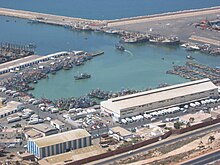
being built. These include the Tangier-Mediterranean port ("Tanger-Med") and its industrial parks, a 45,000-seat sports stadium, an expanded business district, and a renovated tourist infrastructure.
Agriculture in the area of Tangier is tertiary and mainly cereal.
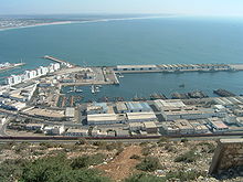
The infrastructure of this city of the strait of Gibraltar consists of a port that manages flows of goods and travellers (more than one million travellers per annum) and integrates a marina with a fishing port.
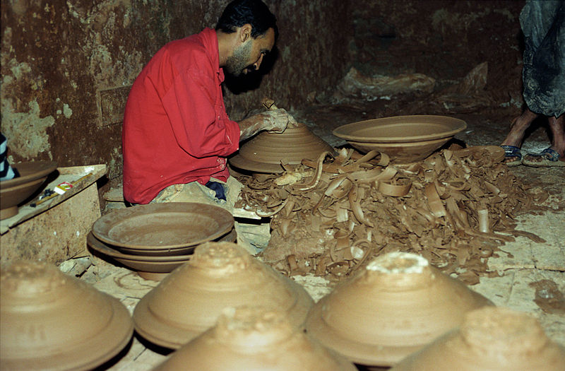
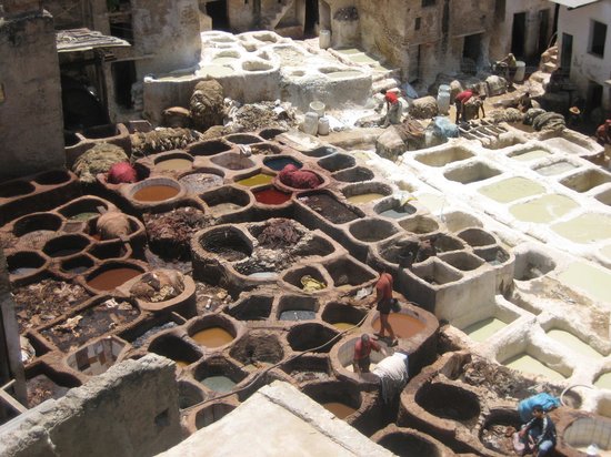
Artisanal trade in the old medina (old city) specializes mainly in leather working, handicrafts made from wood and silver, traditional clothing, and shoes of Moroccan origin.
The city has seen a fast pace of rural exodus from other small cities and villages. The population has quadrupled during the last 25 years (1 million inhabitants in 2007 vs. 250,000 in 1982).[citation needed] This phenomenon has resulted in the appearance of peripheral suburban districts, mainly inhabited by poor people, that often lack sufficient infrastructure. The city's postcode is 90 000.

Notable landmarks

American Legation entrance
mosquée des Andalous
  • Dar el Makhzen (Sultan's palace)
  • Tangier American Legation Museum
  • Museum of Moroccan Arts and Antiquities
  • Museum of Contemporary Art (Tangier)
  • Fondation Lorin
  • Musée de Carmen-Macein
  • Tangier Grand Mosque
  • Kasbah Mosque
  • Petit Socco souk
  • Grand Socco
  • Hotel Continental (Tangier)
  • Church of the Immaculate Conception
  • Anglican Church of St. Andrew
  • Rue Es-Siaghine
  • Rue de la Liberté
  • Avenue Pasteur
  • Ancien Palais du Mendoub
  • Gran Teatro Cervantes
  • Quartier du Marshan
  • Colline du Charf
  • Parc de la Mendoubia
  • Café Hafa

Transport

A railway line connects the city with Rabat, Casablanca and Marrakech in the south and Fès and Oujda in the east. The service is operated by ONCF. The Rabat-Tanger expressway connects Tangier to Fès via Rabat 250 kilometres (155 miles), Settat via Casablanca 330 km (205 mi) and Tanger-Med port. The Ibn Batouta International Airport (formerly known as Tangier-Boukhalef) is located 15 km (9 mi) south-west of the city centre.
The new Tanger-Med Port is managed by the Danish firm A. P. Moller-Maersk Group and will free up the old port for tourist and recreational development.
Tangier's Ibn Batouta International Airport and the rail tunnel will serve as the gateway to the "Moroccan Riviera" the coast between Tangier and Oujda. Traditionally the north coast was an impoverished and underdeveloped region of Morocco but it has some of the best beaches on the Mediterranean and is likely to see rapid development.
The Ibn Batouta International Airport has been being expanded and modernized to accommodate more flights. The biggest airline at the airport is Royal Air Maroc. In addition, a TGV high-speed train system is being built. It will take a few years to complete, and will become the fastest train system in North Africa.

Language

Most of the inhabitants of Tangier speak the Moroccan Arabic dialect. About 25% of the city inhabitants speak Berber in their daily lives. Written Arabic is used in government documentation and on road signs together with French. French is used in universities and large businesses. English and Spanish are well understood in all hotels and tourist areas.

Education

Tangier offers four different types of educational systems: Arabic, French, Spanish and English. Each of these systems offer classes starting from Pre-Kindergarten up to the 12th grade, Baccalaureat, or High school diploma.
Many universities are located both inside and outside the city. Universities like the "Institut Superieur International de Tourisme" (ISIT), which is a school that offers diplomas in various departments, offer courses ranging from business administration to hotel management. The institute is one of the most prestigious tourism schools in the country. Other colleges such as the "Ecole Nationale de Commerce et de Gestion" (ENCG-T) is among the biggest business schools in the country as well as "Ecole Nationale des Sciences appliquées" (ENSA-T), a rising engineering school for applied sciences.

Primary education

There are more than a hundred Moroccan primary schools, dispersed across the city.

International primary institutions

  • The American School of Tangier
  • École Adrien Berchet
  • Colegio Ramón y Cajal (Spanish primary school)
  • English College of Tangier
  • Tangier Anglo Moroccan School

International high schools

  • The American School of Tangier
  • Lycée Regnault de Tanger (French High School)
  • Instituto Severo Ochoa (Spanish High School)
  • English College of Tangier
  • Mohammed Fatih Turkish School of Tangier
  • Tangier Anglo Moroccan School

In popular culture

Notable people

Ibn Battuta was a Moroccan Muslim scholar and traveler
  • Ibn Battuta – Moroccan Muslim scholar and traveler
  • Ralph Benmergui – Canadian TV and radio host at the Canadian Broadcasting Corporation
  • Paul Bowles - American writer, composer and ethnomusicologist
  • William S. Burroughs Beat Generation Writer, wrote Naked Lunch in the early 1950's in Tangier
  • Alexandre Rey Colaço – Portuguese pianist
  • Karim Debbagh – Moroccan Film producer
  • Roger Elliott – first British Governor of Gibraltar
  • Bibiana Fernández – Spanish actress and model
  • Antonio Fuentes – Painter described as the 'Picasso of Tangier'[1]
  • Sanaa Hamri – Moroccan music video director
  • Emmanuel Hocquard – French poet
  • Jean-Luc Mélenchon – French politician, currently MEP
  • Alexander Spotswood – American Lieutenant-Colonel and Lieutenant Governor of Virginia
  • Heinz Tietjen – German music composer
  • Abderrahmane Youssoufi – former Prime Minister of Morocco
  • Abdullah al-Ghumari - Muslim cleric

Events

  • Tanjazz – An annual international Jazz festival.
  • Festival National du Film – An annual Moroccan film festival (8th edition in 2006).
  • Le Festival International de Théâtre Amateur – An international amateur theater festival.
  

Hercules Cave

  
The caves of Hercules, located just 14kms west of Tangiers, are a place of stunning natural beauty and great archeological significance.

Apparently, this is where the mythical figure, Hercules, used to rest after finishing his 12 labours.

The mouths of the caves open up onto the Atlantic and are flooded at high tide. When the tide comes in, water gushes up through these massive holes in the ground and hillside. It's very impressive.

The caves are partly man-made and partly natural. It's not exactly sure how the caves were created. It's believed that for some reason, an ancient civilization used to carve millstones out of the solid rock that caused giant caves to form over the years. How these primitive people managed to cut into solid rock with simple and crude tools is still a mystery.
At low tide, the views inside caves looking out over the ocean are stunning, the colours in particular. The blue Atlantic Ocean and sky above resemble a reverse silhouette of Africa.

Swimming here can be quite dangerous.
 The currents offshore can get very strong. If you're not a strong swimmer, it's best to stick to sunbathing.

Some people say that the caves were once joined under the sea to St Michaels caves on the rock of Gibraltar and that this is "possibly" how the Barbary Apes crossed over. But nobody knows for sure. This coastline is also where the pirates of the region were once headquartered.

Also well worth a visit is the old 2nd and 3rd century Roman ruins of Cotta. They're just 500 feet away

lundi 2 décembre 2013

FEZ City

FEZ


Fes
or Fez (Arabic: فاس‎, Moroccan Arabic [fɛs], Berber: Fas, ⴼⴰⵙ) is the third largest city of Morocco, with a population of approximately 1 million (2010). It is the capital of the Fès-Boulemane region.
The city has two old medinas, the larger of which is Fes el Bali. It is listed as a UNESCO World Heritage Site and is believed to be one of the world's largest car-free urban areas.[3] Al-Qarawiyyin, founded in AD 859, is the oldest continuously functioning madrasa in the world. The city has been called the "Mecca of the West" and the "Athens of Africa".

History

Etymology

Until the rule in the 11th century, Fes consisted of two separate cities or medinas: Madinat Fas and Al-'Aliya, the former being founded by Idris I, the latter by his son, Idris II. During Idrisid rule the capital city was known as Al-'Aliya, with the name Fas being reserved for the separate site on the other side of the river: no Idrisid coins have been found with the name Fes, only al-'Aliya and al-'Aliya Madinat Idris. It is not known whether the name al-'Aliya was ever used to refer to both medinas. It wasn't until 1070 that the two agglomerations were united and the name Fas was used for both sites.
The name is probably taken from the word Fazaz, the old Berber name for the Middle Atlas mountains near the city. The name is also attested as that of a Berber tribe living just south of Fes. Today, Ait Fazaz is the name of a small town just west of Meknes.

Foundation and the Idrisids

The city was founded on a bank of the Jawhar river by Idris I in 789, founder of the Zaydi Shi'ite Idrisid dynasty. His son, Idris II (808),[6] built a settlement on the opposing river bank. These settlements would soon develop into two separate, walled and largely autonomous sites, often in conflict with one another: Madinat Fas and Al-'Aliya. In 808 Al-'Aliya replaced Walili as the capital of the Idrisids.
Arab emigration to Fez, including 800 Andalusi families of Berber descent[7] in 817–818 expelled after a rebellion against the Umayyads of Córdoba, and 2,000 Arab families banned from Kairouan (modern Tunisia) after another rebellion in 824, gave the city a more Arabic character than other cities of the region. The Andalusians settled in Madinat Fas, while the Tunisians found their home in al-'Aliya. These two waves of immigrants would subsequently give their name to the two sites: 'Adwat Al-Andalus and 'Adwat al-Qarawiyyin.[8] An important aspect of the city's population was of North-African Berber descent, with rural Berbers from the surrounding countryside settling the city throughout this early period, mainly in Madinat Fas (the Andalusian quarter) and later in Fes Jdid.
Upon the death of Idris II in 828, the dynasty’s territory was divided among his sons, and the eldest, Muhammad, received Fes. The newly fragmented Idrisid power would never again be reunified. During Yahya ibn Muhammad's rule in Fes the Kairouyine mosque, one of the oldest and largest in Africa, was built and its associated Al-Qarawiyyin Madrasa was founded (859).[10] Comparatively little is known about Idrisid Fes, owing to the lack of comprehensive historical narratives from this period and the fact that little has survived of the architecture and infrastructure of early Fes (Al-'Aliya). The sources that mention Idrisid Fes, describe a rather rural one, not having the cultural sophistication of the important cities of Al-Andalus and Ifriqiya.
In the 10th century the city was contested by the Caliphate of Córdoba and the Fatimids of Tunisia, who ruled the city through a host of Zenata clients. The Fatimids took the city in 927 and expelled the Idrissids, after which their Miknasa were installed there. The Miknasa were driven out of Fes in 980 by the Maghrawa, their fellow Zenata, allies of the Caliphate of Córdoba. It was in this period that the great Andalusian ruler Al-Mansur Ibn Abi Aamir commissioned the Maghrawa to rebuild and refurnish the Al-Kairouan mosque, giving it much of its current appearance. According to the Rawd al-Qirtas and other Marinid era sources, the Maghrawi emir Dunas Al-Maghrawi filled up the open spaces between the two medinas and the banks of the river dividing them with new constructions. Thus, the two cities grew into each other, being now only separated by their city walls and the river flowing through them. His sons fortified the city to a great extent. This could not keep the Almoravid emir Ibn Tashfin from conquering the city in 1070, after more than a decade of battling the Zenata warriors in the area and constant besieging of the city.

Golden age and the Marinid period

Madinat Fas and Al-'Aliya were united in 1070 by the Almoravids: the walls dividing them were destroyed, bridges connecting the two parts were built and connecting walls were constructed that unified the medinas. Under Almoravid patronage the largest expansion and renovation of the Al-Kairouan mosque took place (1134-1143). Although the capital was moved to Marrakech and Tlemcen under the Almoravids, Fez acquired a reputation for Maliki legal scholarship and became an important centre of trade. Almoravid impact on the city's structure was such that the second Almoravid ruler, Ibn Tashfin, is often considered to be the second founder of Fes.[11]
Like many Moroccan cities, Fes was greatly enlarged in the Almohad era and saw its previously dominating rural aspect lessen. This was accomplished partly by the settling there of Andalusians and the further improvement of the infrastructure. At the start of the 13th century they broke down the Idrisid city walls and constructed new ones, which covered a much wider space. These Almohad walls exist to this day as the outline of Fes el Bali. Under Almohad rule the city grew to become the largest city in the world between 1170 and 1180, with an estimated 200.000 people living there in that period.[12]
In 1250 Fes regained its capital status under the Marinid dynasty. In 1276 they founded Fes Jdid, which they made their administrative and military centre. Fez reached its golden age in the Marinid period, which marked the beginning of an official, historical narrative for the city.[13][14] It is from the Marinid period that Fes' reputation as an important intellectual centre largely dates.[15] They established the first madrassas in the city and country.[16][17] The principal monuments in the medina, the residences and public buildings, date from the Marinid period.[18] The madrasas are a hallmark of Marinid architecture, with its striking blending of Andalusian and Almohad traditions. Between 1271 and 1357 seven madrassas were built in Fes, the style of which has come to be typical of Fassi architecture. The Jewish quarter of Fes, the Mellah was built in 1438, near the royal residence in Fes Jdid. The Mellah at first consisted of Jews from Fes el Bali, but soon saw the arrival of Berber Jews from the Atlas range and Jewish immigrants from Al-Andalus. In 1465 a large pogrom happened during which nearly all the Jews of Fes were murdered.[19][20] The Marinids spread the cult of Idris I and encouraged sharifism, financing sharifian families as a way to legitimize their (in essence secular) rule: from the 14th century onwards hundreds of families throughout Morocco claimed descent from Idris I, especially in Fes and the Rif mountains. In this regard they can be seen as the enablers of the latter sharifian dynasties of Morocco. A revolt in 1465 overthrew the last Maranid sultan and in 1474 the Marinids were replaced by their relatives of the Wattasid dynasty, who faithfully (but for a large part unsuccessfully) continued Marinid policies.[21]

Modern period

In the Early Modern Age, the Ottoman Empire came close to Fez after the conquest of Oujda in the 16th century. In 1554, the Wattasid Dynasty took Fez with the support of the Turks, and the city became a vassal of the Ottomans, who finally conquered it in 1579 under sultan Murad III.[22]
The Ottoman power in North Africa focused on threats posed by Habsburg Spain and the Portuguese Kingdom. As a result, Fez was not under pressure from the Ottoman rulers. The conquest of Fez was the catalyst for the move of the capital city of the Saadi Dynasty to Marrakech. Early in the 17th century the town returned to Moroccan control under Ahmad al-Mansur.[23]
After the fall of the Saadi Dynasty (1649), Fez was a major trading post of the Barbary Coast of North Africa. Until the 19th century it was the only source of Fez hats (also known as the tarboosh). Then manufacturing began in France and Turkey as well. Originally, the dye for the hats came from a berry that was grown outside the city, known as the Turkish "kızılcık" or Greek "akenia" (Cornus mas). Fez was also the end of a north-south gold trading route from Timbuktu. Fez was also a prime manufacturing location for leather goods such as the Adarga.
The city became independent in 1790, under the leadership of Yazid (1790–1792) and later, of Abu´r-Rabi Sulayman. In 1795 control of the city returned to Morocco. Fez took part in a rebellion in 1819-1821, led by Ibrahim ibn Yazid, as well as in the 1832 rebellion led by Muhammad ibn Tayyib.
Fez was again the capital of Morocco until 1912. Rabat remained the capital even when Morocco achieved independence in 1956.
Despite the traditional character of most of the city, there is also a modern section, the Ville Nouvelle, or "New City". Today that is a bustling commercial center. The popularity of the city has increased since the King of Morocco took a computer engineer from Fes, Salma Bennani, as his wife

Climate

Fez has a Mediterranean climate. Located by the Atlas Mountains, Fez has a seasonal climate, shifting from cold and rain in the winter to dry and hot days in the summer months between June and September. The nights are always cool (or colder in winter). Rainfall can reach up to 700 mm (28 in) per year, snow can also fall in winter The winter highs typically reach only 16 °C (61 °F) in December–January, The highest and lowest temperatures ever recorded in the city are 46.7 °C (116 °F) and −9.2 °C (15 °F), respectively

University of al-Karaouine

University of al-Karaouine.
The University of al-Karaouine or al-Qarawiyyin (Arabic: جامعة القرويين) is the oldest continually operating university in the world.[26] The al-Karaouine mosque was founded by Fatima al-Fihri in 859 with an associated school, or madrasa, which subsequently became one of the leading spiritual and educational centers of the historic Muslim world.[27] It became a state university in 1963 and remains an important institution of learning today.[28]

Transport

The city is served by Saïss Airport. It also has an ONCF train station with lines east to Oujda and west to Tanger and Casablanca.

Sport

Fes Stadium.
Fes has a football team, MAS Fez. They play in the Botola the highest tier of the Moroccan football system. They play their home matches at the 45,000 seat Complexe Sportif de Fès stadium.

Notable residents

  • Muhammad XII of Granada, last Moorish king of Al-Andalus.
  • Jamal Fakir, French international rugby league player.
  • Madame Guinaudeau, French cookery and travel writer.
Fes
Fas / ⴼⴰⵙ / فاس
Fez
View of the medina (old city) of Fes

Flag
Fes is located in Morocco
Fes
Location in Morocco
Coordinates: 34°2′N 5°0′WCoordinates: 34°2′N 5°0′W
Country  Morocco
Region Fès-Boulemane
Founded 789
Founded by Idrisid dynasty
Government
 • Mayor Hamid Chabat
 • Governor Mohamed Rerrhabi
Elevation 1,900 ft (579 m)
Population (2012)
 • Total 1,044,376
 • Population Rank in Morocco 3rd
Racial makeup
 • Arab 57.1%
 • Berber 32.7%
 • Moriscos 10.2%
Website www.fes-city.com

dimanche 1 décembre 2013

Agadir

                                                     Agadir
Agadir (Berber: Agadir, ⴰⴳⴰⴷⵉⵔ; Moroccan Arabic: اگادير‎) is a major city in southwest Morocco, the capital of Agadir-Ida Ou Tanane province (MA-AGD) and of the Souss-Massa-Drâa economic region some 508 km to the south of Casablanca, 173 km from Essaouira and 235 km to the west of Marrakech[1] A majority of its inhabitants speak Berber as their mother tongue.
The city is located on the shore of the Atlantic Ocean, near the foot of the Atlas Mountains, just north of the point where the Sous River flows into the ocean.


Introduction

The city of Agadir together with the neighbouring cities of Inezgane and Ait Melloul was estimated in 2013 to have 609,088 inhabitants
According to the 2004 census, there were 346,106 inhabitants in that year and the population of the Prefecture of Agadir-Ida Outanane was 487,954 inhabitants
Agadir is one of the major urban centres of Morocco, the seventh largest conurbation of the country after Casablanca, Rabat, Fez, Marrakech, Meknes, and Tangier. The population density is quite high. Three languages are spoken in the city: Arabic (mainly Darija, which is the Moroccan Arabic dialect); Ta-Chelh-it (or Shilha Berber) by the Berbers (who are also known as I-Mazigh-en Berbers or Ch'leuhs: I-Celḥiy-en); and French. The mayor is Tariq Kabbaj.
Destroyed by earthquake in 1960, the city has been completely rebuilt with mandatory seismic standards. It is now the largest seaside resort in Morocco, where foreign tourists and many residents are attracted by an unusually mild year-round climate. Since 2010, it has been well served by low cost flights and a Motorway from Tangiers, the city attracts all walks of life and has had an annual growth rate of over 6% per year in housing demand while housing production barely exceeds 3.4%
The mild winter climate (January average midday temperature 20.5°C/69°F) and good beaches have made it a major "winter sun" destination for Northern Europeans.

Etymology

The word Agadir means in Berber "wall enclosing a fortress or town".
Agadir's name is Gadiris in French, and pronounced Gougadir or Oultougadir in Berber language (Tachelhit), and Gadiri or Gadiria in Arabic (pronunciations are approximate - see original Tachelhit and Arabic for accuracy).


The name of Agadir comes from the GDR Berber root meaning slope, steep slope, or escarpment

Districts of Agadir

Fog in Agadir
The current conurbation of Agadir is actually a combination of four communes:
  • the former town of Agadir city
  • the urban commune of Anza
  • the rural town of Ben Sergao and
  • the rural town of Tikiwine

The city centre

Large and dynamic, it includes the boulevards Mohammed V and Hassan II, the Valley of Birds, the avenues General Kettani, Mohammed VI, Moulay Abdellah, and Mokhtar Soussi as well as the main avenue of the FAR ( Royal Armed Forces of Morocco). The city centre also includes the Place Salam, Place de l'Esperance, the Loubnane Mosque, and the Square with two fountains that leads to the greenbelt of the municipality. With the combination of several communes, the city centre is process to gradually move towards the Haut Founty district where the new administraton have built a new building for the Court of Appeal.

The seaside

Lively and dynamic, the tourist area at the seaside consists of the boulevard of 20 August, Tawada Avenue, the Corniche, Avenue of Oued Souss, and the Founty district: Baie des Palmiers. It has many hotels, restaurants, trendy cafes, and residential villas.
A large beautification project for the city is in course of being completed. Agadir is well equipped with a beautiful waterfront promenade about 5 km long.
A recent marina with many luxury shops was built at the foot of the Casbah and at the beginning of the Oued Tildi.

New Talborjt

This area is known as the old district of Talborjt (meaning "small fort" in tachelhit, in remembrance of the water tower which was first built on the plateau in the former Talborjt). Lively, the New Talborjt which has been rebuilt away from the Old Talborjt, has as a main artery the Boulevard Mohammed Sheikh Saadi, who was the victor against the Portuguese in 1541. Other major avenues are the Avenue President Kennedy and the Avenue February 29. There is also the Mohammed V mosque, the Olhão garden (Olhão is a coastal city located in the south of Portugal, which is paired with Agadir) and its memorial museum and the garden Ibn Zaydoun. Some good hotels and restaurants have been built on the main arteries.

Residential districts

  • Swiss Village: the oldest district of villas bordered by the Avenue of FAR (Royal Armed Forces), Avenue Mokhtar Soussi, Cairo Avenue, and the Avenue of the United Nations.
  • Mixed Sector District: the French and Spanish Consulates are in this district.
  • Founty or "Bay of palm trees": a seaside area with residential villas, large hotels, holiday homes, and the royal palace.
  • High Founty: a new district of buildings and residential villas, located in the new city centre between the new Court of Appeal and the Marjane supermarket.
  • Illigh: to the east in front of the Hassan II hospital, is a residential area of large villas, housing the "new bourgeoisie".
  • Charaf: The Hassan II hospital is in this district.
  • Les Amicales: also known as the "city of bureaucrats".
  • Dakhla: close to the faculty of Ibnou Zohr, it has a great mix between modern buildings, ordinary villas, and studio apartments.
  • Hay Mohammadi: a new urbanization zone in Agadir with a villa zone and a zone for large groups of buildings to frame the extension of the Avenue des FAR in the northwest.
  • Adrar City: a new district next to the Metro hypermarket.
  • Other neighborhoods: Lakhyam, Massira, Alhouda, Tilila, Tassila, Ben Sergao, Riad Assalam, Islane, Ihchach (Yachech) Nahda, Anza, and Taddart.

Ports

The Fishing Port seen from the Casbah
Over the decades, Agadir has had several ports: two fishing ports, a major trading port, and the recent port for leisure boats with its marina.
The Avenue du Port, the main artery of the Anza district, is surrounded by canneries and has many popular small restaurants adjacent to the fish market.
The fishing port is one of the premier major sardine ports in the world. The commercial port is also known for its exports of cobalt, manganese, zinc, and citrus products.

The Casbah or Agadir Oufella

Hill of the old Casbah
The Casbah at Night
The Casbah (Agadir Oufella, Agadir le haut, Agadir N'Ighir, or Agadir de la colline) was, along with Founti by the sea, the oldest district of Agadir. An authentic fortress with winding streets and lively, the Casbah was built in 1572 by Moulay Abdallah al-Ghalib. Above the front door; today, the original inscription in Arabic and in Dutch reads: "Fear God and honour the King."
Of this fortress there remains, after the earthquake of 29 February 1960, a restored long high wall that surrounds land that is not buildable. The view, however, is exceptional over the bay of Agadir and the ports. The old people of Agadir remember the famous "Moorish café" of the Casbah and its panoramic view.
The hill bears the inscription in Arabic: "God, Country, King" which, like the walls, is illuminated at night.

Old Talborjt

Overlooking the waterfront and Wadi Tildi, this old district (whose name is sometimes spelled Talbordjt) was once a shopping area and very lively with its large square where there was a weekly market, hotels, schools, mosque[8] 90% of the buildings in Old Talborjt were destroyed or severely damaged by the earthquake in 1960. Razed to the ground after the earthquake and now overgrown, it is classified as non-buildable area. Its main thoroughfare, the Avenue El Moun stretches over 2 km and serves only for driving schools who teach their students to drive.

The Abattoir (Industrial area)

Spices
One of the most popular neighbourhoods, it is known for its Square for taxis and buses. It is a junction that unites the heart of the city and its surroundings. This district was the least affected by the earthquake of 1960.

Souk El Had

This is the largest market in the region. It has about 6,000 small shops. It is surrounded by walls and has several entrances. It is organized into different sectors: furniture, crafts, clothing, vegetables, meat, spices etc. It is possible to find little marvels, including all kinds of handicrafts and traditional decorations. There are also objects of poor quality "made in China", imitation traditional slippers in plastic at ridiculous prices, and counterfeit articles.
The walls have been restored and the interior design is being finished.

La Médina

La Médina
La Médina is a handicrafts space created in 1992 by the Italian artist Coco Polizzi, at Ben Sergao, a district close to Agadir 4.5 km from the city centre. Built using techniques of traditional Berber construction, it is a kind of small open-air museum, on five hectares and home to artisan workshops, a museum, individual residences, a small hotel, and an exotic garden.

Climate

Sunset in Agadir
Agadir features a subtropical-semiarid climate (Köppen: BSh ) with warm summers and mild winters. Located along the Atlantic Ocean, Agadir has a very temperate climate. The daytime temperature generally stays in the 20s °C (70s °F) every day, with the winter highs typically reaching 20.4°C (70°F) in December–January (see weather-table below). The annual temperatures are very similar to Nairobi, Kenya, but with much less rainfall -about 10 inches annually- and the mid-year nights are less chilly than the Kenyan Capital.
Occasionally however, the region experiences winds from the Sahara called Chergui, which may exceptionally and for a few days (2-5) raise the heat above 40°C.
The lowest temperature recorded in Agadir was -2.6°C and the highest maximum recorded was 49.1°C at Agadir airport on 30 July 2009
In 1950, a poster from the Navigation Company Pacquet proclaimed: "Winter or summer, I bathe in Agadir"

Economy

Agadir fishing port
Agadir's economy relies mainly on tourism and fisheries. Agricultural activities are based around the city.[25]
Agadir has one of the biggest Souks in Morocco (Souk Lhed)
The city has a cement company called Ciments du Maroc (CIMAR), a subsidiary of the Italian group Italcementi[26] which is in process of being transferred to a new plant 40 kilometres from the city. There is also a shipyard in the port and the only Merchant Marine school in Morocco.

Transportation

Agadir is served by Al Massira Airport, located 22 kilometres from the city. With the opening of the new Casablanca–Agadir expressway in June 2010, which runs from Casablanca via Marrakech to Agadir, access to the region is much improved.
For freight there is also a port, and for pleasure-craft there is a marina in Agadir.

Culture

The Timitar festival, a festival of Amazigh and music from around the world, has been held in Agadir every summer since its inception in July 2004.
The Morocco Movement association is involved in the arts and organizes concerts, exhibitions and meetings in the visual arts, design, music, graphic design, photography, environment and health[27]
Other cultural events in Agadir are:
  • Noiz Makerz concert of urban music.
  • Breaking South National championship inBreak-dancing
  • International Documentary Film Festival in November (FIDADOC)
  • Film Festival for immigration
  • International Festival of University Theatre of Agadir
  • Concert for Tolerance (November)
  • Festival of Laughter

Museums

Mosque Loubnan in Agadir
  • Musée de Talborjt "La Casbah"
  • Musée Bert Flint
  • Le Musée des Arts Berberes
  • Musee Municipal de Agadir
  • La Medina d'Agadir

Education

The city of Agadir has a university: the University Ibn Zuhr which includes a Faculty of Science, Faculty of Law, Economics and Social Sciences, the Faculty of Arts and Humanities, and the multi-disciplined Faculty of Ouarzazate.
There are also establishments of higher education such as:
  • the National School of Applied Sciences (ENSA)
  • the National School of Business and Management (ENCG)
  • the Graduate School of Agadir technology (ESTA).
There is an international French school: the French School of Agadir and also public schools: Youssef Ben Tachfine School, Mohammed Reda-Slaoui School, and the Al-Idrissi Technical College.
There is a range of highschools:
  • Groupe Scolaire Paul Gauguin Agadir
  • Groupe Scolaire LE DEFI
  • Lycée Lala Meryem Agadir
  • Lycée Qualifiant Youssef Ben Tachfine
  • Lycée Technique Al Idrissi
  • Lycée Al Qalam
  • Lycée Al Hanane
  • Lycée Français d'Agadir
  • Lycée Anoual
  • Lycée Zerktouni
  • Lycée Mohamed Derfoufi

Sport

  • See Hassania Agadir the Agadir football club and
  • Grand Stadium of Agadir the new stadium for Agadir.
The Botola side Hassania Agadir is the local football team of Agadir. They play their home matches at the Stade Al Inbiaâte.

Notable natives and residents

  • Abbes Kabbage (died 1 May 1984) was a regional leader of the Istiqlal Party before joining the UNFP in 1960.
  • Abdelaziz Lahrech (18 November 1918-14 March 1994), the PDI regional leader of the Party for Democracy and Independence
  • Mohammed Khair-Eddine (1941-1995), Moroccan writer
  • Abdellah Aourik, painter.
  • Val Fouad, author of "Agadir", published by Editions Alan Sutton.
  • Dominique Strauss-Kahn spent his childhood there from 1951 to 1960.
  • Saphia Azzedine, screenwriter and writer, born in 1979 in Agadir[28]
  • Jacques Bensimon, Canadian filmmaker, was born in Agadir
  • Michel Vieuchange, French adventurer and explorer, died in Agadir in 1930

Beaches outside Agadir

Agadir beach
Some of the most beautiful beaches in Morocco are located to the north of Agadir. Areas also known for excellent surfing are located near Taghazout village to Cap Ghir. Many smaller and clean beaches are located along this coast. Some of them between Agadir and Essaouira are: Agadir Beach, Tamaounza (12 km), Aitswal Beach, Imouran (17 km), Taghazout (19 km), Bouyirdn (20 km), Timzguida (22 km), Aghroud (30 km), Imiouadar (27 km).[29]

Places to visit

  • The view of the city and the bay from Agadir Oufella (Casbah)
  • Bert Flint Museum on Boulevard Mohammed V
  • Valley of the Birds, a pleasant bird park stretching along the Avenue of Administrations, between Boulevard Hassan II and 20 August
  • The garden of Ibn Zaidoun
  • Mohammed V Mosque, on the Boulevard President Kennedy
  • Souk el Had
  • The little train of Agadir: circuit around the city
  • Amazigh (Berber) Heritage Museum at the Ayt Souss Square
  • The garden of Olhão or "Garden of Portugal" and its memorial museum in Talborjt
  • The marina with its Moorish architecture and shops

Nearby attractions

  • The city of Taroudant 80 km to the east, along the Souss valley
  • Imouzzer Ida Ou Tanane a small toewn 60 km northeast of Agadir
The beaches of Taghazout and Tamraght. A large tourism development project in the Bay of Taghazout, Taghazout-Argana Bay was launched in 2007.
  • The city of Tiznit 90 km to the south and Tafraout 80 km from Tiznit, a magnificent site of pink granite rocks
  • The Souss-Massa National Park and Oued Massa, about 70 km to the south and the fishing village of Tifnit
  • Sidi Ifni, 160 km south of Agadir on the coast
  • The city of Essaouira 175 km north of Agadir on the coast

Movies filmed in Agadir

  • 1934: Le Grand Jeu by Jacques Feyder
  • 1954-1955: Oasis by Yves Allégret
  • 1969: Du soleil plein les yeux by Michel Boisrond
  • 1988: Y'a bon les blancs by Marco Ferreri
  • 2006: Days of Glory by Rachid Bouchareb
  • 2009: Les Filles du désert by Hubert Besson, an episode of the television series Plus belle la vie
  • 2011 Agadir Bombay by Myriam Bakir
                                                      Agadir oufella at night !

Likes